Stone Living Lab Launches Major Expansion of Network That Monitors MA Coastal Conditions and Tracks Flooding
Media Contacts: Alexis McLean, Stone Living Lab, amclean@bostonharbornow.org; Peter Howe, Denterlein, phowe@denterlein.com
FOR IMMEDIATE RELEASE
BOSTON, Mass., August 12, 2026 – Massachusetts is taking a big leap forward in its ability to monitor coastal conditions and flooding through a major expansion of a network of overland flood sensors and offshore wave buoys operated by the Stone Living Lab at UMass Boston.
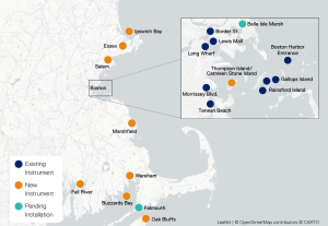
The Stone Living Lab – a research partnership led by UMass Boston and Boston Harbor Now, along with City, State, and Federal partners – is completing the installation of 10 new overland flood sensors and two offshore buoys measuring wave conditions at locations from Cape Ann to Boston to Buzzards Bay to the Cape and Islands.
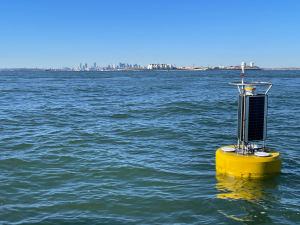
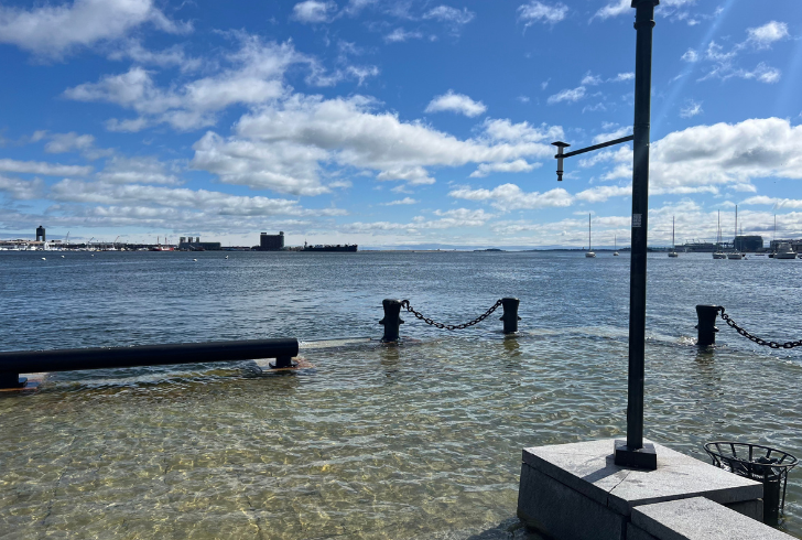
Left: A Stone Living Lab Hohonu overland flood sensor at Long Wharf in Boston; Right: A Stone Living Lab wave buoy in Boston Harbor.
The new instruments more than double the reach of the Real-Time Monitoring Network being developed by the Lab, filling in major gaps in ocean and flood monitoring. The expanded monitoring will provide local leaders, climate scientists, and residents with publicly accessible real-time and localized data about where communities and residents may face damaging floodwaters at high tides and during coastal storms.
“The Stone Living Lab has been committed to transformative research and outreach that can help make vulnerable coastal regions adaptive to climate change and enhance natural environments. The expanded Real-Time Monitoring Network marks a leap forward in fulfilling that mission, especially with the intuitive, easy-to-navigate dashboard that makes all this data readily accessible and visually understandable for all kinds of stakeholders,” said Dr. Katie Dafforn, Director of the Stone Living Lab and Distinguished Professor of Coastal Resilience at UMass Boston.
The 10 new Hohonu overland flood sensors are being deployed in: Fall River, Salem, Essex (which has two sensors), Thompson Island (proposed as Cathleen Stone Island) in Boston Harbor, Marshfield, Wareham, Falmouth, Oak Bluffs, and one other location to be finalized north of Boston. The second sensor in Essex is a “mobile sensor” that will be installed in a new location every 4-6 months. The two new wave buoys, deployed near Ipswich in Ipswich Bay and near Mattapoisett in Buzzards Bay, provide 24/7 monitoring of wave height, frequency, and direction, useful for both long-term modeling and early warnings of possible coastal flooding.
With the new installations, the Real-Time Monitoring Network now includes overland flood sensors, wave buoys, tide gauges, and weather stations in a total of 22 locations throughout Boston and Eastern Massachusetts. (Please see attached map for full details.) The network of sensors complements other sensors in Massachusetts and helps form a robust coast-wide flood monitoring system, which is a strategy in the Commonwealth’s ResilientCoasts initiative.
“The Healey Administration was pleased to contribute $200,000 to support this important expansion of the network to monitor flooding and coastal conditions,” said Secretary of Energy and Environmental Affairs Rebecca Tepper. “The data the network provides is critical to enhancing our resilience to storms and flooding that are made worse by climate change.”
“The expansion of the Stone Living Lab’s Real-Time Monitoring Network provides more opportunities to understand where coastal flooding is happening and worsening, so that we can continue to collaboratively plan for and adapt to a changing climate,’’ said Joe Christo, Chief Resilience Officer at the Stone Living Lab and Boston Harbor Now. “Projects like this do not happen without close partnerships, and we are so thankful to have many great partners throughout Massachusetts and beyond that we collaborate with on this work.”
The network will produce more frequent data points that will help inform and improve models predicting the coastal flooding risks the state faces from rising sea levels, storm surges, and other effects of climate change. Data collected by the network are publicly available on new dashboards that can be found at www.stonelivinglab.org/dashboards.
“Our goal with the dashboards is to translate that real-time data from the network into information that is not only accessible to the public, but easy to understand. We hope that displaying this data in a digestible way will allow community members and municipal planners to be more informed and prepared during flooding events,” said Katie Zarada, Data Scientist at the Stone Living Lab.
“In many cases flood data are only collected during the largest storms and at limited locations. The Real-Time Monitoring Network being established by the Stone Living Lab provides expanded spatial observations and captures more frequent flooding occurring during smaller storm events and high tides,” said Kirk Bosma, Senior Coastal Engineer and Vice President at Woods Hole Group, and Engineering Director at the Stone Living Lab. “These data not only provide useful real-time flood information to manage instantaneous flood risk but also provide much needed data that can be used to create accurate predictive models giving flood warnings 7 to 10 days in advance.”
“The Town of Essex is very pleased to be chosen to host a site as part of the Real-Time Flood Monitoring Network. This installation fulfills a critical goal found within the Town’s Municipal Vulnerability Preparedness Plan while contributing data that will be helpful to coastal resilience planners in other jurisdictions and organizations,” said Brendhan Zubricki, Essex Town Administrator. “We are looking forward to linking to the digital dashboards that will be offered for our own planning and research purposes and for the benefit of the public and others.”
The Stone Living Lab and its technical consultants at Woods Hole Group and Hohonu have coordinated closely on the project with the Massachusetts Executive Office of Energy and Environmental Affairs and Office of Coastal Zone Management, the City of Boston, and multiple coastal municipalities. Funding for this project has been provided by the James M. and Cathleen D. Stone Foundation and 11th Hour Racing, and funding for the expansion of the project has been provided by the Massachusetts Executive Office of Energy and Environmental Affairs and Office of Coastal Zone Management.
-30-
Interview Information
Photos of the Real-time Monitoring Network can be found at the following link. Please reach out to Alexis McLean or Peter Howe for questions about captions. Please credit the Stone Living Lab or Dominique Sindayiganza as indicated in file names.
https://drive.google.com/drive/folders/1af0niN_WLWCRMWsPNqHRURq9ucNdORMM
Contact Alexis McLean or Peter Howe to arrange an interview with one or more of the Stone Living Lab project representatives:
About Stone Living Lab
The Stone Living Lab (SLL) is an innovative and collaborative initiative focused on testing and scaling up nature-based approaches to climate adaptation in Boston Harbor and beyond. We are a unique partnership between government agencies and nonprofits: UMass Boston School for the Environment, Boston Harbor Now, the City of Boston, the Massachusetts Department of Conservation and Recreation, the Massachusetts Executive Office of Energy & Environmental Affairs, and the National Park Service, and we work in consultation with the Massachusett Tribe at Ponkapoag. As a “Living Lab,” we bring research into the real world by engaging scientists and the community in collaborative design and exploration. Our work brings us not only along the coastline of Boston Harbor, but into the water itself and out among the Boston Harbor Islands and other locations. Our areas of focus are research and monitoring, education and engagement, policy innovation, and climate preparedness.
Map of Instruments