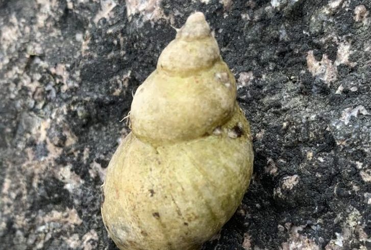
Oceans rise. Coastlines fall. When you’re a hungry dog whelk, what do you think of it all?
By Jarrett Byrnes
My job as part of the Stone Living Lab is to think about the organisms that live in and around the areas we hope to implement nature-based shoreline preservation. Relative to who lives there now, which algae and animals will be the big winners? Who are the big losers? Will it all say the same? You may say that the price of a change is a price that you’re willing to pay… but when push comes to shove, what will a fully transformed shoreline look like? Will it remind you of the one you love, here and now? Will it look different, but be robust and resilient to other future changes coming our way?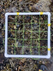
To answer this, we’re harnessing the magic of the Before-After Control-Impact (BACI) study. Let’s say you want to understand if a power plant outfall, where water used to cool the plant is released back into the sea, is changing the ocean around it. In science, to understand if something is having an effect on the world around it, we like to look at lots of examples of the phenomena and compare them to many examples of an unchanged control area to see if, on average, there is something going on. But, you can’t replicate a power plant! What you can do, though, is look at the power plant and adjacent control areas before and after the impact of installing the outfall. Does life in the ocean fluctuate through time in the same at the outfall as it does everywhere else? Or is something different going on.
So, to understand if our proposed efforts to protect the shoreline at Rainsford Island will lead to a more robust resilient intertidal or something else, my lab has spent this summer setting up a BACI monitoring design with George’s, Gallops, and Peddocks as our control islands.
It’s been wild.
First off, as with any new program, there are a million bugs to work out. We’ve been deploying a Remotely Operated Vehicle (ROV) to see what habitats are like underwater as well as get good crab counts. More on that from Laura Dissly, our ROV superhero, in another post.
There’s the fun of having to work tides, getting out early in the morning on UMass Boston boats – with all of the scheduling and caffeination fun that entails.
There’s the challenge of timing things just right so that the tide doesn’t swallow up the plots you’re sampling before you’re done. Which is extra tough if your low tide is right before sunrise!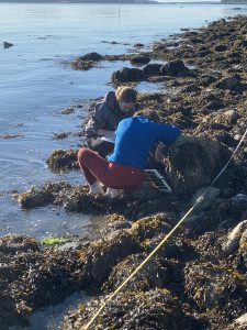
We’ve also been designing our protocols on the fly to adapt to the unique environments of the Boston Harbor Islands. We’ve been attempting to use emerging international sampling standards and techniques from the Global Ocean Macroalgal Observing Network, (an organization I’ve been involved in via the Global Ocean Observing System), but this process requires constant refinement and adaptation in the field.
There’s biological surprises, such as the bodaciously dense mussel beds on the islands. This discovery was a shock, as mussels have not been doing so well in the Gulf of Maine as of late. The inner harbor islands are lower wave action sites with calmer water – sites that should be dominated by just algae, and not mussels.
But through it all, as the team has started from scratch and developed a solid sampling program for the future, we’ve gotten beautiful data. We’ve started to map what species are where as a baseline.
And with this baseline, over the next few years, who knows what changes we’ll see – both at Rainsford and at the control islands.
Because we’ll be back. Soon we’ll see…we’ll use our data to remember what should be. And for that little dog whelk on the shore: now, when push comes to shove, will our solutions be good for its friends and family, as it were, creating a better shoreline to love? That’s our hope – to see that we can build strength and resilience using solutions inspired by nature.
Jarrett Byrnes is a Stone Living Lab researcher and professor of marine ecology at UMass Boston.