September Flooding Coverage
The Lab was featured in several pieces about the Perigean Spring Tides between September 19 – 21, 2024.
Check out the stories below.
Boston’s roadways and docks have only just dried after the latest King Tide, and facing a future of higher sea level rise and more flood events, the city is doubling down on a combination of permanent and short-term solutions to shore up its coastline. Some of those temporary options – known as deployable flood barriers – will be showcased in a novel city tour on Friday…
“We always need to be planning for coastal adaptation across the city, and looking at it at a broad scale, but also on a site-by-site basis as well,” said Joe Christo, managing director of the climate resilience-focused Stone Living Lab. “I think that you really need to have a network of different approaches to address Boston’s 47 miles of coastline.”
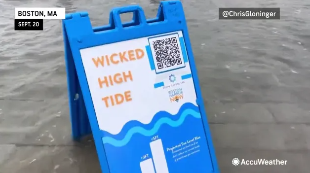
A coastal flood advisory is in effect today up and down the eastern Massachusetts coast, as the king tides reach their peak. The seasonal phenomenon is expected to bring tides two feet higher than normal to the Boston area. There’s also a high surf advisory in effect, so officials are urging people to be cautious along the shore.
Go deeper: The tides are caused by the lunar orbit, but magnified by the effects of climate change, says Rebecca Shoer, a program manager with the research nonprofit Stone Living Lab. “These have been happening for millennia, as long as there’s been a moon and a sun and an earth, but it’s compounded on top of sea level rise,” Shoer told WBUR’s John Bender. “Boston has already had about 10 inches of sea level rise, which means when these really high tides happen, we see flooding in the city.”
High tide across Boston’s waterfront reached about 12 feet high relative to low tide on Thursday and Friday afternoons, a phenomenon that — for now — can only occur a few times a year when the planets (literally) align.
At high tide around 1:30 p.m. on Friday, the water easily overtopped Long Wharf’s sea wall downtown, intriguing tourists and thrilling at least two local dogs that went for a brief swim. In Dorchester, low-lying Morrissey Boulevard was partially flooded Friday afternoon, slowing traffic as cars crawled through the water.
Scientists say that while the phenomenon is exceptional now, this level of flooding could become common in the coming decades if climate change continues to worsen.
“What we’ve got here is kind of a glimpse into what Boston’s future could look like,” said Rebecca Shoer, senior program manager for a climate adaptation research group called the Stone Living Lab, talking to a curious crowd taking photos on the wharf.
A coastal storm has been lurking off the East Coast of the United States for five days, contributing to persistent coastal flooding, rip currents and rough surf from North Carolina to Maine.
Boston Harbor rose to minor flooding stage at the National Weather Service (NWS) tidal gauge for each high tide between Thursday and Sunday afternoon. The peak on Saturday afternoon put local businesses and roads underwater, as videos showed.