Real-Time Monitoring Field Observations: Fall River Flooding on June 23, 2026
Contributors: Katie Lavallee, Katie Zarada, Alexis McLean
Overview
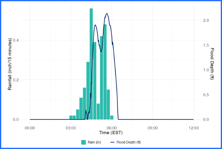
Heavy rainfall during the early morning hours of June 23 caused flooding in Fall River. The Stone Living Lab’s overland flood sensor installed over Quarry Street in Stafford Square recorded over 2 feet of flooding during the storm.
The flood sensor readings aligned with the precipitation recorded by the USGS Fall River gauge (USGS-414204071091700), which recorded 2.75 inches of rain between 2:25 am and 6:00 am on June 23 with over half an inch of rain falling between 4:30 am and 4:45 am.
Data from Stone Living Lab Stafford Square Overland Flood Sensor
Flood depth captured by the Stafford Square overland flood sensor (blue) and rainfall data from USGS Fall River Precipitation Gauge (teal).
Data collected from the Lab’s flood sensor in Stafford Square showed that flooding increased rapidly to 1.91 ft between 4:15 am and 4:48 am following intense rainfall of 0.56 inches over a 15 minute period. Over the next 30 minutes, as the rainfall rate decreased, flood levels receded to 1.36 ft, before once again increasing to a maximum flood depth of 2.14 ft at 5:38 am following another 0.9 inches of rain. Flooding receded over the next hour, lasting until 6:34 am. The total flooding event lasted 2 hours and 15 minutes, with over 1 ft of water on the roadway for 1 hour and 15 minutes.
This is the first sensor installed by the Stone Living Lab in partnership with Woods Hole Group that is designed to capture precipitation-based flooding. With a Flood Watch in effect today across southern Massachusetts, Stone Living Lab researchers are closely monitoring flood height data collected through our Real-time Monitoring Network.
Read more about the impacts of the June 23 flooding event in local news coverage.