In Eastie, an early glimpse at Boston’s existential and expensive struggle to hold back the sea | Boston Globe
After two consecutive months that brought with them coastal flooding during storm events, local media has been very interested in covering the phenomenon.
The Lab’s Research Director Paul Kirshen is featured in a Boston Globe story focused on East Boston’s efforts to mitigate flooding. Read the story below.
The multi-billion dollar plan is raising tough questions about climate preparedness and gentrification.
Just above a rocky shoreline in East Boston is a housing development built on elevated land so that its residential entrances are 14 feet above mean high tide and much less vulnerable to flooding.
The Clippership Wharf development offers a glimpse of how Boston’s shoreline could soon change under the city’s ambitious strategy to protect coastal neighborhoods from a warming planet and the rising Atlantic Ocean.
The boxy mid-rise buildings provide front-row ocean views, above a landscape that includes terraced salt marshes that act as a buffer. Hailed as an example of climate-resilient housing, the total cost of the development was more than $200 million.
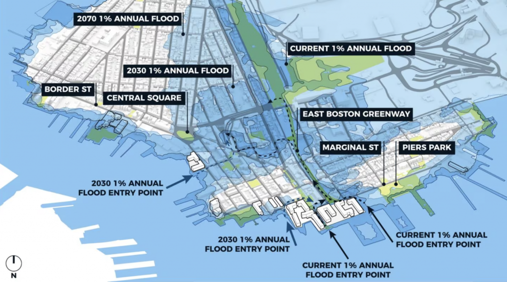
The map shows how floodplains in East Boston expand as climate change worsens. Areas with a 1 percent chance of flooding each year are in the floodplain. The darkest blue shading shows the current floodplain; the lighter shade shows the floodplain in 2030; and the lightest blue shows the floodplain in 2070. COURTESY OF THE CITY OF BOSTON
But the transforming coastline raises tough questions about Boston’s broader “Climate Ready” plan: Will it be enough to prevent flooding, will private developments built under its policies accelerate gentrification in flood-prone neighborhoods, and how will the city pay for necessary public improvements, such as flood walls and elevated roads?
East Boston, the city’s most flood-vulnerable neighborhood, is the proving ground.
To address sea level rise, city planners envision a mix of public and private projects that, like a skinny jigsaw puzzle, would fit together to create one long coastal barrier: elevated streets, flood barriers disguised as sloping parks, and new developments on higher ground.
In other words, plug all the holes along the coastline where seawater could penetrate. The total cost, though, could be more than $3 billion.
“Are we going to be ready? I don’t know,” said Ellen Douglas, lead author of Boston’s foundational climate impact report that the city used to guide its strategy.
Climate scientists expect the long-held international target of keeping the planet below 1.5 degrees Celsius of warming, compared to the preindustrial era, is probably out of reach. Still, with strong action to cut greenhouse gas emissions, global warming could be limited to about 2 degrees.
For Boston, 2 degrees could mean anywhere from about 5 inches to more than 60 inches of sea level rise by 2070.
Already the seas along the Boston shoreline reach about 3 inches higher than in 2000; scientists and policymakers believe that about 9 more inches over the next few decades are unavoidable. So, for planning purposes, the city picked a rise of 40 inches, or about 3.5 feet, by 2070.
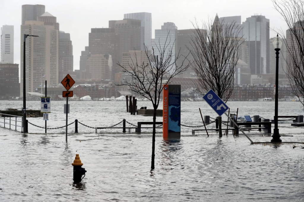
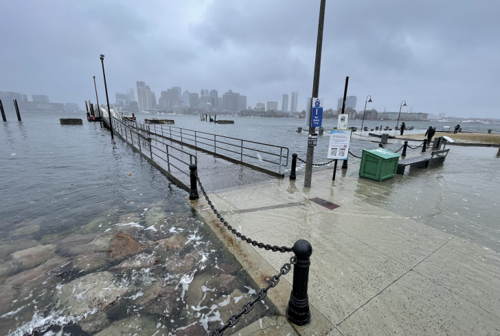
Water flooded a street in East Boston during high tide on Dec. 23. Boston’s “Climate Ready” projects to protect neighborhoods from such flooding as climate change worsens would cost more than $3 billion, according to the city. The projects would be financed by federal, state and local governments, and by some private developers and businesses that own the land. MICHAEL DWYER/ASSOCIATED PRESS
If that 40-inch figure comes to pass, thousands of homes in East Boston would be affected by flood waters during severe storms, according to a city analysis, and with no additional protection, lead to losses of hundreds of millions of dollars annually.
For neighborhoods most at risk — South Boston, East Boston, Downtown and the North End, Dorchester, and Charlestown — a planning process identified the vulnerable areas in each and the corresponding public or private engineering projects that could protect them.
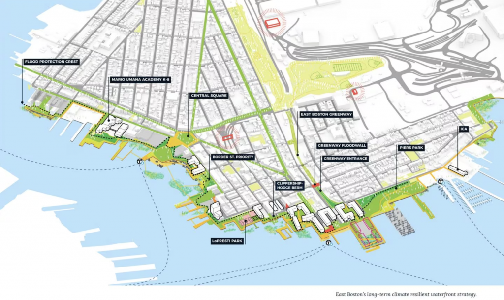
Projects that city planners expect could protect East Boston from sea level rise and coastal flooding are shown as part of the city’s final report on coastal adaptation for the neighborhood. The “Climate Ready” plan lays out a skinny jigsaw puzzle of elevated streets, deployable flood barriers, berms disguised as sloping parks, and new developments built on higher ground to protect neighborhoods from the encroaching sea. COURTESY OF THE CITY OF BOSTON
Much of the land that needs fortifying is privately held, and Boston’s climate strategy continues to allow developers to build right on the water. That has irked some environmental advocates who say the land should not be redeveloped, but rather restored as a natural barrier.
But Catherine McCandless, a climate resilience project manager for the city, says the projects will protect the communities and, in many cases, create new public green spaces.
“Assuming we can move forward with all the projects that we’re intending to, I think we will be able to preserve the safety and functionality of these different neighborhoods,” McCandless said.
East Boston is almost completely surrounded by water. The bustling peninsula is home to Boston Logan International Airport, an ecologically important salt marsh, and more than 45,000 residents, most of them Latino, and many of them immigrants.
Now, after years of planning, it’s time to come up with the money.
The biggest holdup: Boston is waiting on a study by the US Army Corps of Engineers, a prerequisite to unlocking federal funds necessary for dozens of small projects.
Stacia Sheputa, a spokesperson for Boston’s environmental office, said the Wu administration allocated $111 million for coastal resilience projects, the most in city history. But in East Boston alone, the city expects coastal adaptation projects to cost more than $800 million between now and 2070.
Some are done: An expansion and elevation of Piers Park, which is owned by MassPort, cost $20 million. Others in the offing include a $39 million project along Border Street that would elevate roadways, parks, the HarborWalk and docks, and install flood walls.
Next to the Clippership Wharf condominiums, in an area now called Carlton’s Wharf, rising seas could penetrate a gap between buildings and spread into the interior of Eastie. There, the city imagines flood walls disguised as part of an elevated harbor walk.
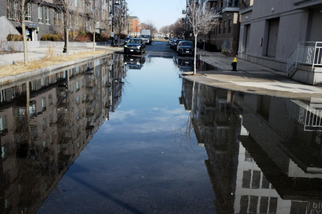
Flooding on Lewis Street in East Boston at high tide. JONATHAN WIGGS/GLOBE STAFF
Sheputa, the city spokesperson, said it’s “difficult to quantify” how much has been spent on climate resiliency in East Boston so far because the waterfront is owned by businesses and various government entities.
Boston is trying to get creative with funding. For the Carlton Wharf project, previously known as the Clippership Hodge Berm, city planners applied to the Federal Emergency Management Agency for funding in 2022, but are still awaiting word.
“I believed … that we would have already been through the FEMA process by now,” the Rev. Mariama White-Hammond, Boston’s chief of Environment, Energy, and Open Space, said during a meeting about coastal resilience in January. “That is a barrier.”
Climate scientists and public policy researchers have largely praised Boston’s little-by-little approach. It’s more flexible than, say, a massive concrete barrier in the ocean (which was studied and discarded as being ineffective and too expensive). It should be easier to finance, too.
Without big dollars from the feds, Boston in the interim is relying on public-private agreements and policy changes to nudge its “Climate Ready” goals along, such as new design guidelines that encourage developers to elevate their buildings.
But Chris Marchi, an environmental activist in East Boston, said that so far, such efforts look more like gentrification than climate resiliency, and asserted the neighborhood’s most pressing needs — including affordable housing and better air quality — are falling to the wayside.
While Mayor Michelle Wu’s administration has greatly expanded the city’s focus on climate issues, Marchi said, “it doesn’t seem like anybody in East Boston is any safer than they were, you know, 10 or 15 years ago.”
Sheputa, the city spokesperson, said the high cost of housing is one of the mayor’s top concerns and noted the city helped fund the East Boston Neighborhood Trust’s acquisition of several multi-family buildings.
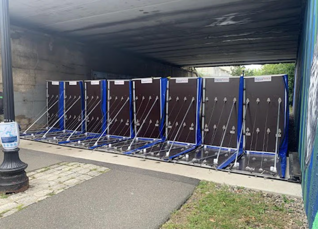
A deployable floodwall partially set up in East Boston’s greenway. The floodwall could be used during a major flood event, and is currently stored at the East Boston Memorial Park, according to a city spokesperson. COURTESY OF THE CITY OF BOSTON
John Walkey, director of waterfront and climate justice initiatives with the community-based organization GreenRoots, called the requirements for developers “minimal.”
He and other environmental advocates want “nature-based” solutions, such as reinforced dunes and restored wetlands, instead of more development right on the coastline.
Sheputa said Boston has a “strong preference” for those strategies.
But in most places along Boston’s shoreline, experts point out, there is little left of nature to enhance: The land is built up, and moreover, not controlled by the city.
Paul Kirshen, a civil engineer and climate adaptation professor at the University of Massachusetts Boston, said the shortage of space to create nature-based solutions is a “killer.”
“The land constraint is really binding right now,” said Kirshen, who is also research director of the Stone Living Lab, an initiative that tests nature-based solutions.
But Walkey, of GreenRoots, thinks it’s more a question of political will.
If a developer offers to put in luxury housing, he said, “it becomes very hard for the city to say no. … [It’s] how the city makes its budget.”