‘Wicked high tides’ are returning, bringing coastal flooding to Boston’s shore and the rest of New England | Boston Globe
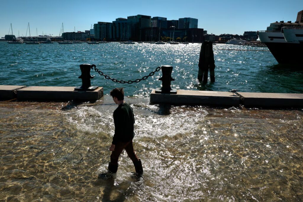
A person wades through the floodwater while taking in the scene during a king tide at the Long Wharf in October 2024.Craig F. Walker/Globe Staff
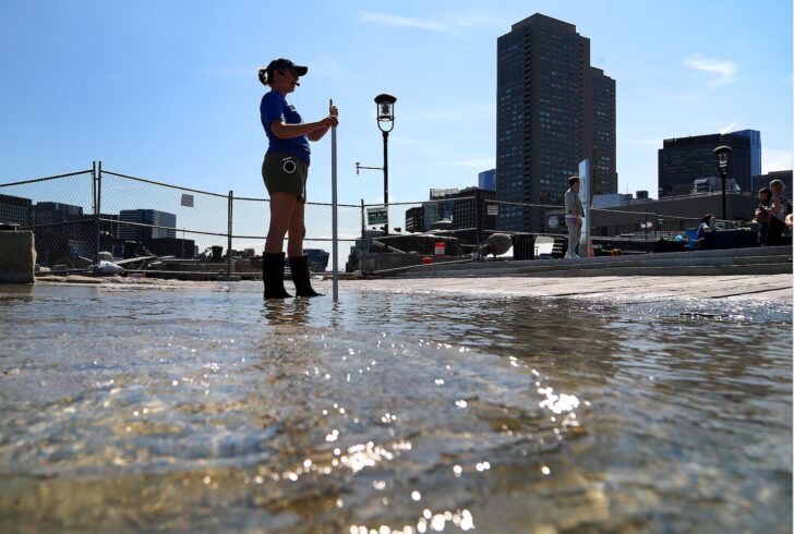
If you live near the coast or have plans to visit the Boston waterfront this week, you may notice water splashing over seawalls and onto walkways, flooding streets, wharfs, and parking lots in the afternoon — the “wicked high tides” are back.
These powerful king tides, the highest tides of the year, will actually wash over the New England coast on several different days this fall and winter, starting with Thursday’s high tide at 2:30 p.m., when water levels are forecast to reach nearly 12 feet, a couple of feet higher than normal, in Boston Harbor.
These exceptional tides occur when the Earth, moon, and sun align, but especially when the moon is also at its closest point to Earth in its monthly orbit — called perigee. This is when the gravitational pull on the Earth is at its strongest, driving high tides 2 to 4 feet above normal and leading to coastal flooding and erosion.
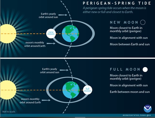
When the sun, moon, and Earth are in alignment while the moon is closest to the Earth, the high tides “spring” up and reach flooding levels. NOAA
I connected with two experts to break down the specifics on king tides and to explore how a changing climate amplifies their impact — William Sweet, an oceanographer with NOAA’s National Ocean Service, and Rebecca Shoer, senior program manager of education and engagement at Stone Living Lab and Boston Harbor Now.
Shoer: “King tides” is a catch-all term used around the world for tides that are much higher than normal. In a place like Boston, which has a pretty wide tidal range, this could be a high tide anywhere from 10 to 12 feet, versus a more typical 8 to 9 feet.
These tides can be caused by all kinds of factors, including storms, but the tides we will experience this week, and then again later this fall, are caused by the astronomical effect known as the perigean-spring tide. Bostonians call this event a “wicked high tide,” our cheeky rebrand of the perigean spring tide to make it approachable and understandable for all of us non-oceanographers.
Sweet: Wicked or king tides are the highest and most predictable tides of the year, since they form in response to forces associated with the Earth-moon-sun geometry that are predictable months to years in advance. Along the Northeast coastline, these typically occur during times when a perigean (moon is at its closest Earth approach) full or new moon occurs (think a super-charged spring tide).
A king tide floods sections of the Long Wharf on Sept. 20, 2024.John Tlumacki/Globe Staff
Shoer: The moon will next be in perigee (that’s “closest to the Earth”) on Wednesday. And we just had a full moon on Sunday. With those two factors combined, we’ll actually see the peak high tide on Thursday, Sept. 11. The tide is predicted to peak at 11.8 feet, which is about 2 or 2.5 feet higher than average, specifically for Boston. Tides lag a bit behind the gravitational pull of the moon and sun — it’s a lot of water moving around!
Sweet: The upcoming high tides on Wednesday and Thursday will be the highest in September. The next round of “wicked high tides” is expected to start hitting the coast between Oct. 8 and 10. These tides will reach over 1.5 feet above the highest average daily tide level (under calm weather conditions).
Globe: Other king tides this fall are expected on Nov. 5-7 and Dec. 3-5. Stone Living Lab runs educational sessions as the king tides rise at Long Wharf through the fall and early winter.
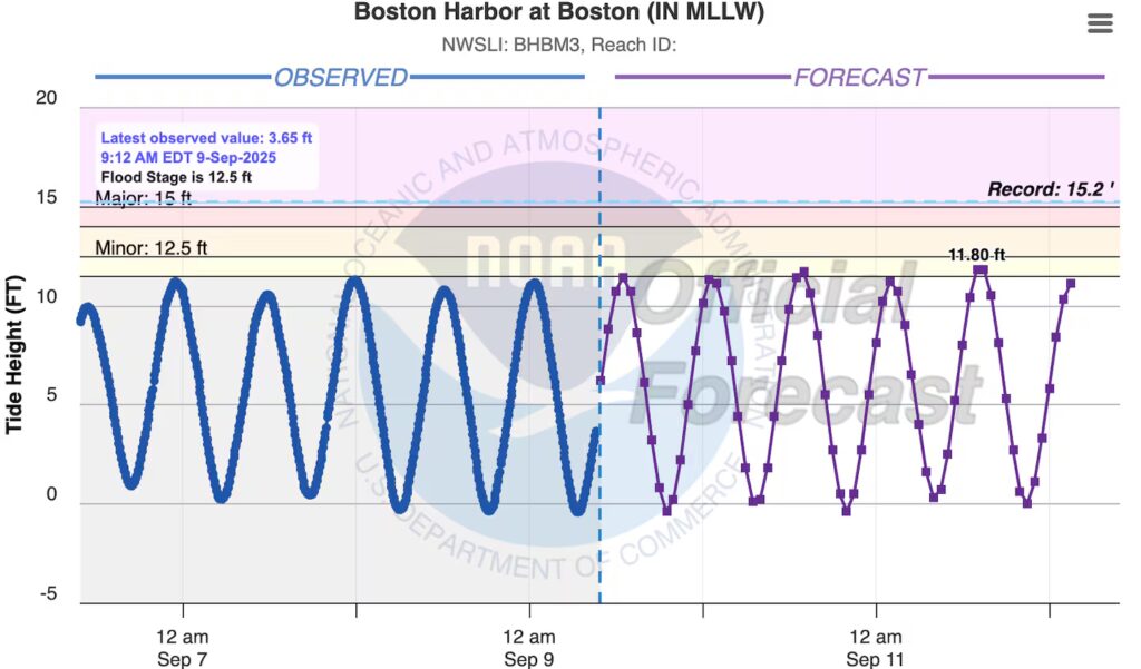
The forecast tides at Boston Harbor over the next couple of days, nearing flood levels. NOAA
Shoer: Rising sea levels are a tremendous concern for coastal communities during these tides. Perigean spring tides have been happening as long as there’s been a moon, sun, and oceans. However, they are now being compounded with sea-level rise from human-caused climate change.
As global temperatures rise and our ice caps melt, so much water is entering our oceans that the ocean is literally rising. And in Boston, it’s already risen almost a foot since the Industrial Revolution (when we started releasing greenhouse gases into the atmosphere). So instead of these wicked high tides nearly reaching the top of Long Wharf, as they did when the wharf was built in the 1700s, it’s now actively flooding the wharf and countless other places around Boston and our surrounding communities.
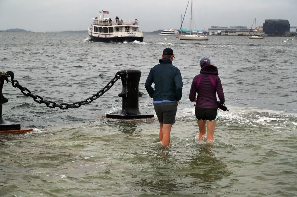
Now, imagine that a nor’easter hits during one of these high tides. We could see water flooding down to Atlantic Avenue, pouring into T stops, reaching into the Shaw’s in East Boston, washing out Morrissey Boulevard. Some folks don’t need to imagine this — just look at the footage from winter storm Riley in 2018.
Anywhere where residences, community centers, businesses, or infrastructure exist along the coast is at risk. It’s our unfortunate legacy that colonists built permanent structures on a naturally dynamic coastal landscape. Soft shorelines erode and transform in response to waves, and that can put people at risk. Hard shorelines and seawalls will redirect wave energy to other places or unintentionally create flood pathways that also put people at risk.
When the high tides arrive this week, folks will get a preview of what a typical daily high tide could look like in 20 or 30 years.
I would say the most surprising thing during the educational sessions I hold is that the event itself can be quite exciting and even joyful. If the sun is shining and the day is calm, Long Wharf is transformed into this watery wonderland where I’ve seen dogs playing and even a kayaker paddling onto the wharf itself.
Folks are amazed and deeply impacted by the sight of the flood, but without the sense of fear that accompanies so many other lived experiences of climate change. It gives a lot more space for creative thinking.
Sweet: Yes, as sea levels continue to rise, so too will the reach of king tides. For instance, by 2050 in Boston, high tide flooding (locally, when water levels are more than 2 feet above the highest average tide) is projected to occur 50 to 70 days annually. Currently, Boston experiences about 10 to 20 days of high tide flooding.
The areas most susceptible to flooding are those that are populated and built on flat and often reclaimed land next to the sea or harbors. A general rule of thumb is: if a location is already feeling the effects of high tide flooding, the impacts will continue to grow in severity — more frequent, deeper, and more widespread.
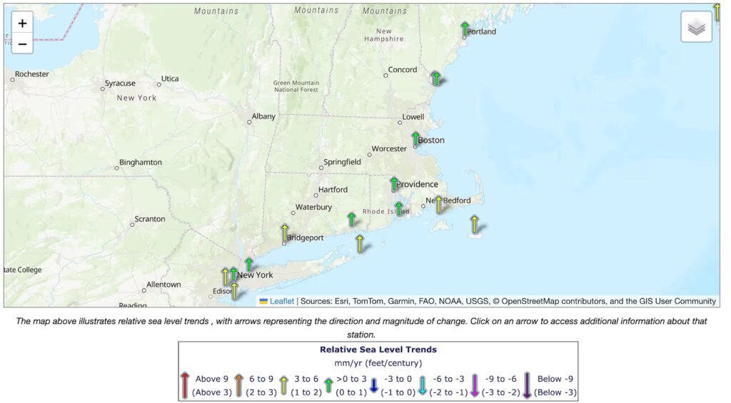
All of New England is seeing sea level rise, with up to a foot more possible in the next century. NOAA
Globe: Sea levels continue to rise, with New England coastal waters rising a couple of millimeters to a few per year. Over the next 100 years, sea levels are expected to rise by a foot or more, which would be devastating to coastal communities. The impacts of the naturally occurring king tides would reach parts of New England that haven’t experienced such flooding before.