Terrestrial LiDAR Scanner (TLS) monitoring of coastal erosion
Project Lead: Francesco Peri
Start Date: 2021
Summary
Coastal erosion is the loss or movement of sediment (sand and mud) and rocks along the coastline, and is caused by the action of waves, currents, tides, and storms. Because erosion can be caused by many different things, it can be difficult to fully understand what erosion is caused by storm events and what is caused by gradual day-to-day processes. For example, the freeze (expansion) and thaw (contraction) cycle of water in winter can lead to slow erosion of coastal bluffs. Additionally, observing erosion can be extremely challenging, as it can appear that no erosion is happening for a long period of time, and then there can be a sudden change (like a whole cliff collapsing in just seconds during a storm).
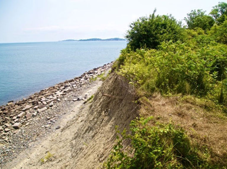
When designing structures that protect our coastlines, it is important to understand all of the factors that cause erosion. This project will utilize Light Detection and Ranging (LiDAR) instruments to capture erosion events as they happen. LiDAR is a tool that measures the amount of time it takes light that comes from a sensor to reflect back from objects in its path, similar to the way a bat uses SONAR to detect the location of objects. This allows the laser-based instrument to create a very accurate 3-dimensional map of the bluff.
We will install a LiDAR monitoring station perched above the cliff on the north shore of Rainsford Island to monitor erosion on an ongoing basis and will make maps before, during, and after storm events to determine erosion during these intense events.
Background
Morphologies of the Boston Harbor Islands (BHI) in New England are dictated by the relative dominance of waves or tides as well as storm events. The intensity, duration, and direction of winds, and, therefore, wind-driven waves, vary seasonally at a given location and spatially alongshore. While tropical storms and hurricanes can alter the BHI coastlines, the primary source of storms is extratropical cyclones (Nor’easters), which can also have dramatically varying intensities and durations.
Understanding the dynamics of coastal erosion is of paramount importance in guiding the design of coastal protections. However, the episodic nature of erosion events makes them particularly difficult to observe and measure. Furthermore, the effect of coastal erosion due to storm events cannot be distinguished from continuous incremental erosion caused by wind and weather, freezing and thawing, and other more gradual (incremental) processes. Light Detection and Ranging (LiDAR) instruments have been quickly emerging as tools that can fill a niche providing robust estimates of various coastal monitoring projects at new spatial and temporal scales.
Research Objectives
The primary outcome of this project will be a platform that can be deployed in multiple locations and also provide data that can be scaled to multiple study sites. The proposed monitoring platform, while designed specifically for Rainsford Island, can be deployed in any portion of coastline with minor modifications. The erosion data that such high resolution, high-temporal monitoring provides augmented with meteorological, tidal, and wave information should be scalable to other systems with similar geomorphology and meteorological conditions. This, in turn, can inform and drive policy and adoption actions through education consistent with multiple Stone Living Lab (SLL) Guiding Principles.
Methodology
We propose to install an autonomous monitoring system to be able to capture erosion events in real time with millimeter accuracy. Observing geological processes is extremely challenging; the seeming absence of anything happening for long periods of time can be contrasted to sudden changes (like a whole section of the cliff collapsing in just seconds during a storm). To monitor such episodic events, we propose to install a fixed Lidar monitoring station perched above the cliff of the north shore of Rainsford island, to observe the fine scale erosion (mm accuracy) of the cliff.
Schedule
The project extends from 2021-2014